What are land use models?
Landuse models are theories which attempt to explain the layout of urban areas. A model is used to simplify complex, real world situations, and make them easier to explain and understand. There is a range of landuse models that apply to urban areas in MEDCS (More Economically Developed Countries).
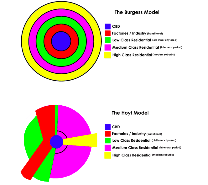
The Burgess Model (1920s) and the Hoyt Model (1940s) are both quite simple models reflecting urban development in the UK:

Both of these models identity similar areas:
1. CBD (Central Business District) – located at the centre of the city often at the convergence of rail and road routes. Contains many commerical activities, shops, entertainment and also business activities.
2. Inner City (also known as the Twilight or Transition Zone) – mixed land-use containing small industries as well as high-density residential land-use – often characterised by terraced housing.
3. Inner Suburbs – residential areas which developed during the 1920s/30s – often semi-detached houses in a distinctive 1920s/30s style with bay windows and front / back gardens.
4. Outer Suburbs – residential areas which grew up later as greater public transport and private car ownership allowed people to live further out from their places of work. These houses are often semi-detached / detached with larger gardens and garages.
5. Rural-urban fringe – this is right on the edge of towns and cities and is mainly low density, private housing (often larger detached properties); new industrial estates / business parks and facilities requiring larger open spaces such as golf courses.
However, both models have limitations. Follow these links for more on these: Burgess and Hoyt.
Later, in the 1950s P.Mann introduced a combination model, called, inspiringly enough, Mann’s Model;
- Mann’s Model
- A British Urban Land Use Model.
- A combination of the ideas of Burgess and Hoyt with both concentric rings and sectors.
- Based on Sheffield, Nottingham and Huddersfield.
- The role of the prevailing wind is important.
- Mann’s Model – Limitations and Advantages
- Once again there is no reference to the physical landscape.
- No acknowledgement of the multiple centres in Harris and Ullman’s model.
- Does not forsee the advent of reurbanisation that is happening today with the regeneration of decaying old industrial centres.
- BUT
- Takes in the role of council estates in the suburbs.
- Notes the influence of environmental factors.
- Makes a model more specific to the UK .
The Harris/Ullman Multi-Nuclei Model is next up, from 1945:
- Harris and Ullman Model
- Otherwise known as the multiple nuclei model.
- Idea that cities are not formed around one CBD but a number of separate nuclei in the urban pattern.
- These nodes become specialised and differentiated based on a number of attributes:
- Differential accessibility. Some activities require specialized facilities such as port and rail terminals.
- Land use compatibility. Similar activities group together. This may be defined as centripetal forces.
- Land use incompatibility. Some activities are repelling each-other such as high quality residential and heavy industrial. This may be defined as centrifugal forces.
- Location suitability. Some activities cannot afford the rent of the optimal site for their location .
- Harris and Ullman Model
- The multiple nuclei model was the first to consider the complexity of the city and its surrounding areas
- Realisation that the CBD is not the only part of a city that affects land use
- Still a simplification of the urban landscape
- Physical landscape still not entirely integrated
There’s a simple but effective review HERE.
Central Place and Bid-Rent Theory complete the collection:
Residential patterns
Growing ethnic segregation in the UK – The Guardian
The Evolution of Urban Planning in 10 Diagrams
Here’s a case study based on Leicester in the UK, as an example of an MEDC country.
There are many rules that try and explain urban hierarchies.
You should have a general understanding of rank size rule, which introduces the concept of urban primacy and Christaller’s central place theory.
Rank size rule: This tells us that in any country there will be one dominant settlement. After this, each settlement will decrease in size according to the rule.
This rule is that the “size of settlement ‘A’ will be equal to the population of the largest settlement divided by rank of ‘A’.”

Therefore, if the largest city has a population of 1,000,000 then the second largest city will have a population of 500,000 then 333,333 then 250,000 and so on.
There are two exceptions to the rule. We can have binary distribution when there are two very large dominant cities (Barcelona and Madrid) and primacy where one city is much larger than any other.
LEDC models:
 Mexico City is a near perfect fit of the Latin American Model City. In fact, Larry Ford and Ernest Griffin made the model in a large part based on Mexico City. This presentation shows how Mexico City operates on this model and as a Primate City in Mexico.


